
- Metals of Interest: Gold & Silver
- Location: Newfoundland
- Surface Area: 21,925 hectares

Bursey & Grub
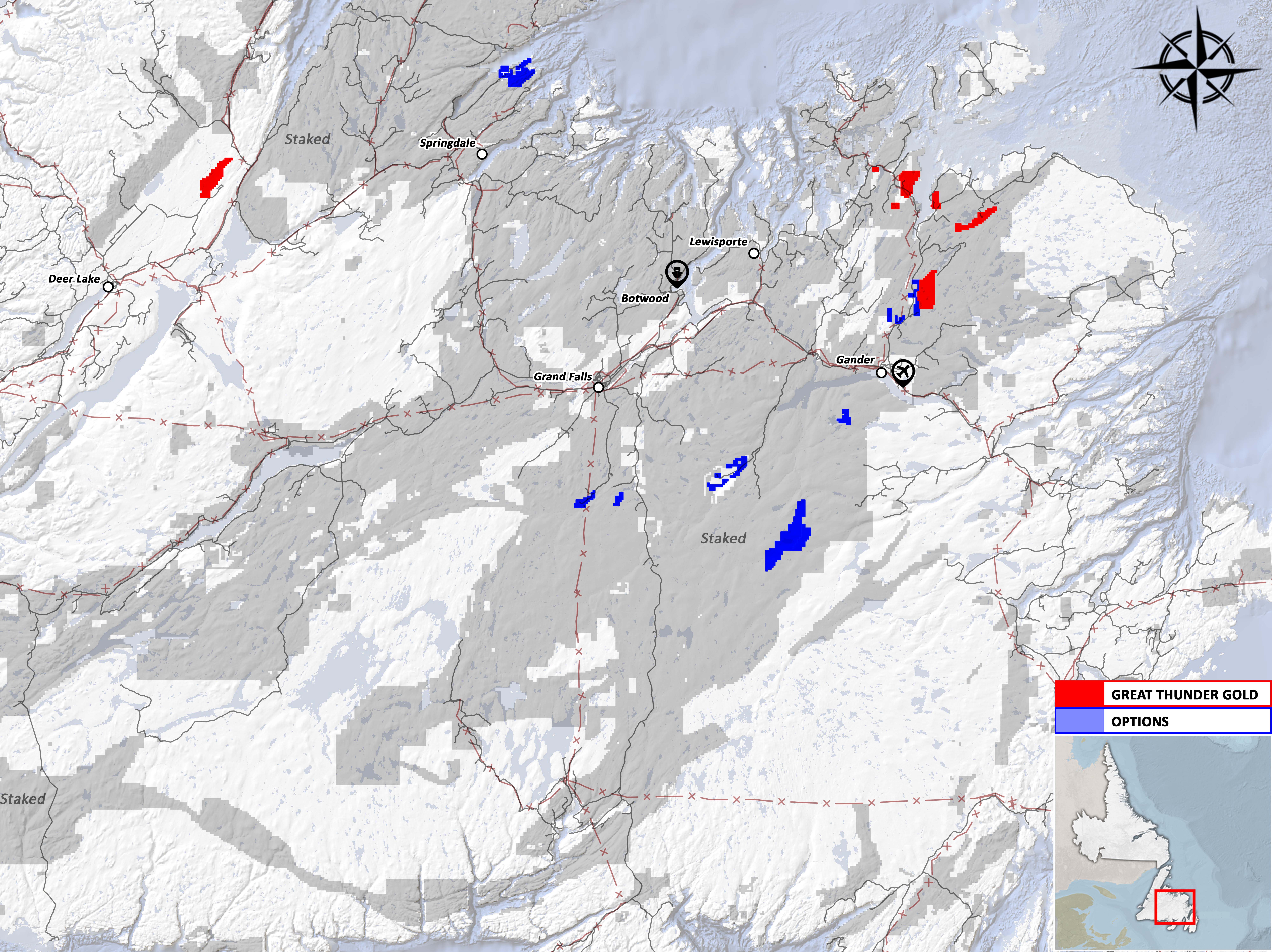
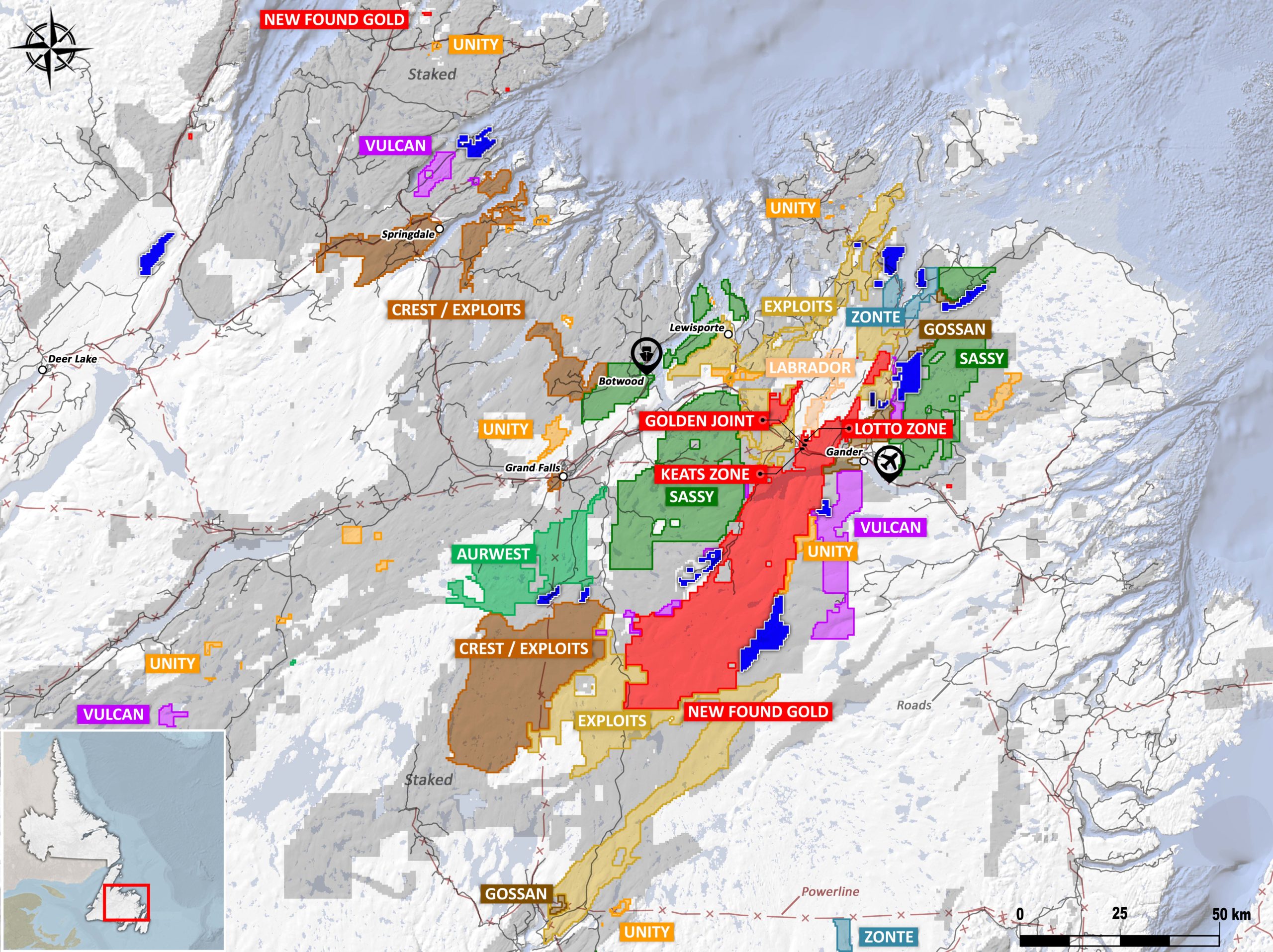
The Property lies along the GRUB Fault, a crustal scale fault zone that divides the Gander Zone from the Exploits Subzone and extends over 200 km in a southwest trend. (Figure 2). The GRUB structural corridor and related splay faulting hosts the Appleton Fault and JBP Fault home to the Queensway Gold Project of New Found Gold that reportedly contains 2 gold discoveries, the Keats and Lotto Zones, and an additional 10 high grade gold showings
The GRUB and Bursey’s Properties are located over and adjacent to a carbonatized ultramafic unit with quartz-carbonate veining known as the Gander River Ultramafic Belt.
Since the initial phase of exploration in the 1980’s no further work has been completed on the claim groups.
Wigwam
The Property lies along the Doucer’s Valley Fault, a crustal scale fault zone that extends from the southwestern tip of Newfoundland 325km northeast to the Jackson’s Arm-Sop’s Arm mineral trend (Figure 2). The Rattling Brook Deposit located south of Jackson’s Arm hosts resources of 255,000 ounces of gold at an average grade of 1.45 gpt Au. Historical exploration on the Wigwam property was for uranium in the early 1980’s, however indications of extensive gold mineralization have been documented by government sponsored lake sediment sampling and coincident pristine gold grains in till samples collected by Altius Resources Inc between 2000 and 2003. Grab samples taken by Inco in 1989 returned gold values ranging from trace to 3.05 gpt Au and Westfield Minerals in 1979 had gold values ranging from trace to 17.89 gpt Au.
Jonathan’s Pond
- The area hosts extremely high gold in tills and heavy mineral concentrates up to 400,000 ppb gold, which has not been sourced.
- Float sample down ice of the claims ran over 700 g/t Au.
Kingsway
- Completely surrounds the Antimony Mine.
- Geophysical anomaly covers the project from the northeast to the southwest.
- Projected mineralized structure extends onto the project’s west border as well as the southeast.
- Located between New Found Gold’s Queensway and Eastern Pond areas.
- Adjacent to the southwest border of New Found Gold, and adjacent to Exploits Discovery and Crest Resources.
Eastern Point
- First mover advantage.
- Assays up to 44 grams of gold in quartz cutting iron sediment which is the same host geology as the past-producing Nugget Pond Mine and Goldenville Mine located to the north-west of the project.
- Adjacent to the Silverdale Mine.
- Directly east of Shoreline Exploration Inc.’s recent staking spree.
- Located less than 50km northeast of the Hammerdown Deposit of Maritime Resources.
Double L
- Adjacent project between New Found Gold and Sassy Resources.
Paradise Lake
- Gold in till identified in the late 1980’s.
- Discovered gold showing in 2001.
- Epithermal boulders in float, has not been sourced.